Weekend availability at Curtis Gulch Campground
Live from Recreation.gov · checked Sep 19, 3:04 PM PTSold out 2 of the next 5 weekends — exactly when cancellation alerts earn their keep.
- Fri, Sep 25Sold out
- Fri, Oct 2Open5/5 sites
- Fri, Oct 9Open5/5 sites
- Fri, Oct 16Sold out
- Fri, Oct 23Limited2/5 sites
Friday + Saturday nights, sites bookable both nights. Counts come from a rotating sweep and can lag a cancellation by up to a day — alerts watch your exact dates within minutes.
How booked is Curtis Gulch Campground?
as of September 20Weekends book out well ahead here — 2 of the 4 Saturdays we sampled, as far out as Oct, are already sold out. When a site frees up it's gone again within minutes, so people watch Curtis Gulch Campground and hear the instant one opens for their dates. Even midweek is filling — 1 of the 3 weekdays we checked are gone.
Weekends (Saturday night)
Weekdays (Wednesday night)
Availability checked directly against the reservation system, out to 3 months ahead.
Campsites & amenities
Site-level details from Recreation.gov's official catalog.
- Campsites
- 6
- Pull-through
- 1
- Max rig length
- 55 ft
About this campground
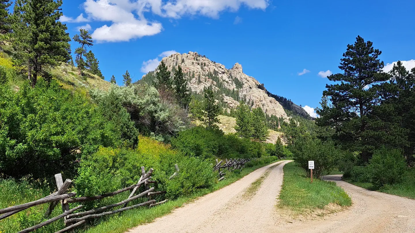
Overview Curtis Gulch Campground sits at an elevation of 6,640 feet, at the end of the long and scenic LaBonte Canyon. There are 6 sites along a bend in the creek with picnic tables, fire rings, pedestal grills, a vault toilet, pump water well, and trash bins. Recreation Recreation The canyon bottom is about 6,700 feet in elevation and has granite rock formations for technical rock climbing and photography. LaBonte Creek runs through the entire length of the canyon and offers anglers many opportunities to catch the rainbow trout stocked annually by the WGFD. For OHV riding, the LaBonte Canyon Trail starts at the back of the campground, and The Big Bear Trail System is located just 1/4 mile up the canyon. Both are 50” or less OHV trails but are also commonly used for hiking, biking, and horseback riding. FSRD #610, Devil's Pass, and the South Fork LaBonte Trails to the south offer additional opportunities for adventure. The Curtis Gulch Trail is non-motorized and starts at the trail parking area just outside the campground. The Laramie Peak Unit of the Medicine Bow National Forest is located in Central Wyoming. The Douglas Ranger District manages the Laramie Peak and Thunder Basin National Grasslands. Year-round recreation uses include hiking, fishing, hunting, climbing, OHV riding, dirt bike riding, camping, biking, and horseback trail riding. Primary access across the district is by I-25 and Highway 59. Mountain Biking • Curtis Gulch Trail • Labonte Canyon Trail • Big Bear Canyon Trails Rock Climbing • Curtis Gulch Trail Day Hiking • Curtis Gulch Trail • Labonte Canyon Trail • Big Bear Canyon Trails Backpacking • Curtis Gulch Trail • Big Bear Canyon Trails • Labonte Canyon Trail Horseback riding • Curtis Gulch Trail • Labonte Canyon Trail • Big Bear Canyon Trails OHV Riding •Labonte Canyon Trail • Devils Pass/South Fork Labonte Trails • Big Bear Canyon Trails Facilities There are 6 sites tucked into a bend of the LaBonte Creek with picnic tables, fire rings, pedestal grills, a vault toilet, pump water well, and trash bins. Natural Features The Curtis Gulch Campground is located at the end of FSRD 658 in LaBonte Canyon. The natural beauty of the steep canyon sides, LaBonte Creek running the length of the entire canyon, and patches of aspen within the mature conifer forest, makes this area one of the most popular and frequently visited on the district. Nearby Attractions LaBonte Creek and Toltec Reservoir offer anglers many fishing opportunities. Brumley FSRD 690, Devil's Pass FSRD 610, and the FSTR 635 S Fork LaBonte trails offer OHV riders additional areas to explore. Charges & Cancellations If I book this reservation today, what are my options to change or cancel? Please remember that reservations at these facilities prevent other visitors from using these sites. Planned changes to your stay should be made as far in advance as possible. You can make changes to your reservation ahead of your arrival date in My Reservations. Changes If your new stay dates are completely different from your original stay dates, there is a $10 change fee (per reserved site). There are no additional fees for: Adding or removing nights to your stay. Changing to a different campsite. Balances will adjust based on your new stay's nightly rate. Cancellations You can cancel the reservation any time before the date of your scheduled arrival. You will receive a refund for your stay, minus the following fees: $10 cancellation fee Any reservation fees (only if paid when booking) Any previous change fees Late cancellation penalties may also apply: What is “Late”? For individual campsites, a late cancellation applies starting from midnight 1 calendar day before your scheduled check-in. For cabins and group sites, a late cancellation applies starting from midnight 14 calendar days or fewer before your scheduled check-in. Late Fee In addition to the fees listed above, a late cancellation will also subtract your first night's recreation use fee from any refund owed. As of the expected check-in day, cancellations or changes to your stay are not possible through My Reservations. It is at the facility's discretion to support additional Late Cancellations, No Show, or Early Departure updates – on-site personnel may not be able to assist. These changes carry penalties and may forfeit recreation use fees. For additional details, please visit here. Scan and Pay Rules The above guidance for modifications, cancellations, and refunds do not apply to campsites reserved using the Scan and Pay feature. There are no refunds, modifications, cancellations, or other fee changes allowed with Scan and Pay payments. This system is the same as putting cash into a fee tube and cannot be refunded.
Getting there
From Douglas WY (30 miles), Take State Highway 91 west then south from Douglas for 22 miles, Converse County Road 16 continuing as Albany County Road 61 south for 14 miles, and east on Forest Road #658 for 4 miles. The pavement ends about 25 miles outside of Douglas and is gravel the remainder of the way, but is easily accessible by car when dry.
Activities
- BACKPACKING
- CAMPING
- CLIMBING
- HIKING
- HORSEBACK RIDING
- HUNTING
- MOUNTAIN BIKING
- OFF ROAD VEHICLE TRAILS
- PHOTOGRAPHY
- SWIMMING
- MOUNTAIN CLIMBING
- OFF HIGHWAY VEHICLE TRAILS
- ROCK CLIMBING
- WATER ACCESS
- BIKING
- FISHING
Nearby federal campgrounds
- Campbell Creek CampgroundMedicine Bow-Routt NFs & Thunder Basin NG11 mi
- La Prele Guard StationMedicine Bow-Routt NFs & Thunder Basin NG11 mi
- Esterbrook CampgroundMedicine Bow-Routt NFs & Thunder Basin NG15 mi
- Rim CampgroundMuddy Mountain Environmental Education Area37 mi
- Lodgepole CampgroundMuddy Mountain Environmental Education Area38 mi
- Shirley Basin ReservoirRawlins40 mi
Never miss an opening at Curtis Gulch Campground
Popular Wyoming campgrounds book out months ahead — but cancellations happen every day. We watch Curtis Gulch Campground around the clock and alert you the moment a sold-out site reopens for your dates, so you don't have to keep refreshing Recreation.gov.
Not ready to subscribe? Get a free weekend heads-up.
We'll email you if Curtis Gulch Campground opens up for a weekend you pick. No account needed.
Details from Recreation.gov's official RIDB catalog. Conditions change — confirm with the managing office or on Recreation.gov before you go. Not affiliated with Recreation.gov or any federal agency.